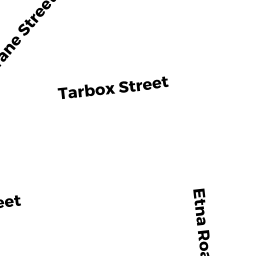
68 TARBOX ST
Owner Information
SELBACH MATTHEW J ETUX
68 TARBOX ST
DEDHAM, MA 02026


Property Details
68 TARBOX ST is classified as a Single Family Residential (Cape cod).
The primary structure on this property was built in 1932. There are 2,881ft2 of built area within this property. There is 1,284ft2 of residential/living space within this property. This property is listed as having 6 rooms.
68 TARBOX ST is valued at $448,700. The land is valued at $239,200 and the structures are valued at $203,600. There is an additional valuation of $5,900 on this property.
This property is in Zone G. Confirm with local Zoning Board authorities to ensure there are no overlays or other easements on this property.
68 TARBOX ST was last sold on Tuesday, April 25, 2017 for $460,000.
Assessment data from fiscal year 2020.
Flood Data
According to the FEMA National Flood Hazard Layer, this property does not appear to be in a flood zone. It may also be in an area not yet reviewed. Nonetheless, confirm this information prior to taking any action.
To view the flood hazards around this property, create a FEMA "Firmette" Map of the area around 68 TARBOX ST.
Broadband Internet Providers
| Provider | Type | Bandwidth (mbps) | |
|---|---|---|---|
| Verizon New England Inc. | DSL | 5 | 0 |
| VSAT Systems, LLC. | Satellite | 2 | 1 |
| HughesNet | Satellite | 25 | 3 |
| GCI Communication Corp. | Satellite | 0 | 0 |
| CenturyLink | Fiber | 0 | 0 |
| RCN | Cable | 1000 | 20 |
| RCN | Cable | 500 | 20 |
| Comcast | Cable | 1000 | 35 |
| Verizon New England Inc. | Fiber | 940 | 880 |
| Viasat Inc | Satellite | 100 | 3 |
| Crown Castle Fiber | Fiber | 0 | 0 |
Broadband service provider data from December 2020.
Adjacent Properties
- 95 CRANE ST
Single Family Residential owned by LAWRENCE PAUL - 103 CRANE ST
Single Family Residential owned by MCLAUGHLIN KENNETH ETUX - 99 CRANE ST
Single Family Residential owned by 99 CRANE ST NOMINEE TRUST - 64 TARBOX ST
Single Family Residential owned by YOUNGSAYE STANLEY ETUX - 76 TARBOX ST
Single Family Residential owned by EMANUEL CHRISTOPHER A ETUX